Drone Surveys
SVV Media for your Drone Surveys
Drone Surveys
What it is and can be used for:
Aerial surveys or Drone Surveys are conducted by drones and revolutionise data collection across diverse projects, offering unparalleled efficiency and precision. Employing cutting-edge technology, our unmanned aerial vehicles capture high-resolution imagery and data, providing a comprehensive perspective. Various projects benefit from drone surveys:
Environmental Monitoring:
Track deforestation, wildlife habitats, and ecosystem health.
Monitor changes in land use and detect environmental degradation.
Agriculture Management:
Optimize crop health assessment and yield prediction.
Evaluate irrigation efficiency and identify pest infestations.
Infrastructure Inspection:
Assess the condition of bridges, power lines, and pipelines.
Identify potential hazards and maintenance needs with enhanced visuals.
Urban Planning:
Evaluate city infrastructure and plan for future development.
Assess traffic patterns and optimize transportation systems.
Construction and Development:
Facilitate site planning and design through topographic mapping.
Monitor construction progress and ensure adherence to plans.
Disaster Response:
Rapidly assess post-disaster damage for efficient response.
Create detailed maps for disaster recovery planning.
These drone-based aerial surveys offer a versatile and cost-effective solution across industries, streamlining data acquisition and analysis for informed decision-making.
Here are some of the service areas we cover:
Residential and Commercial Land
Construction
Insurance
Historical and Heritage
Drone Inspection Videos
We create memories by taking up to 4K video of construction projects for clients to be able to look back on a project for different reasons. Delays, good practise, deliveries of material, moving of earth, digging trenches. All these can be shown to investors and members in the boardroom at their own time. We can can do Live Feed Viewing in most areas, it is ideal for marketing purposes as well as Insurance claims.
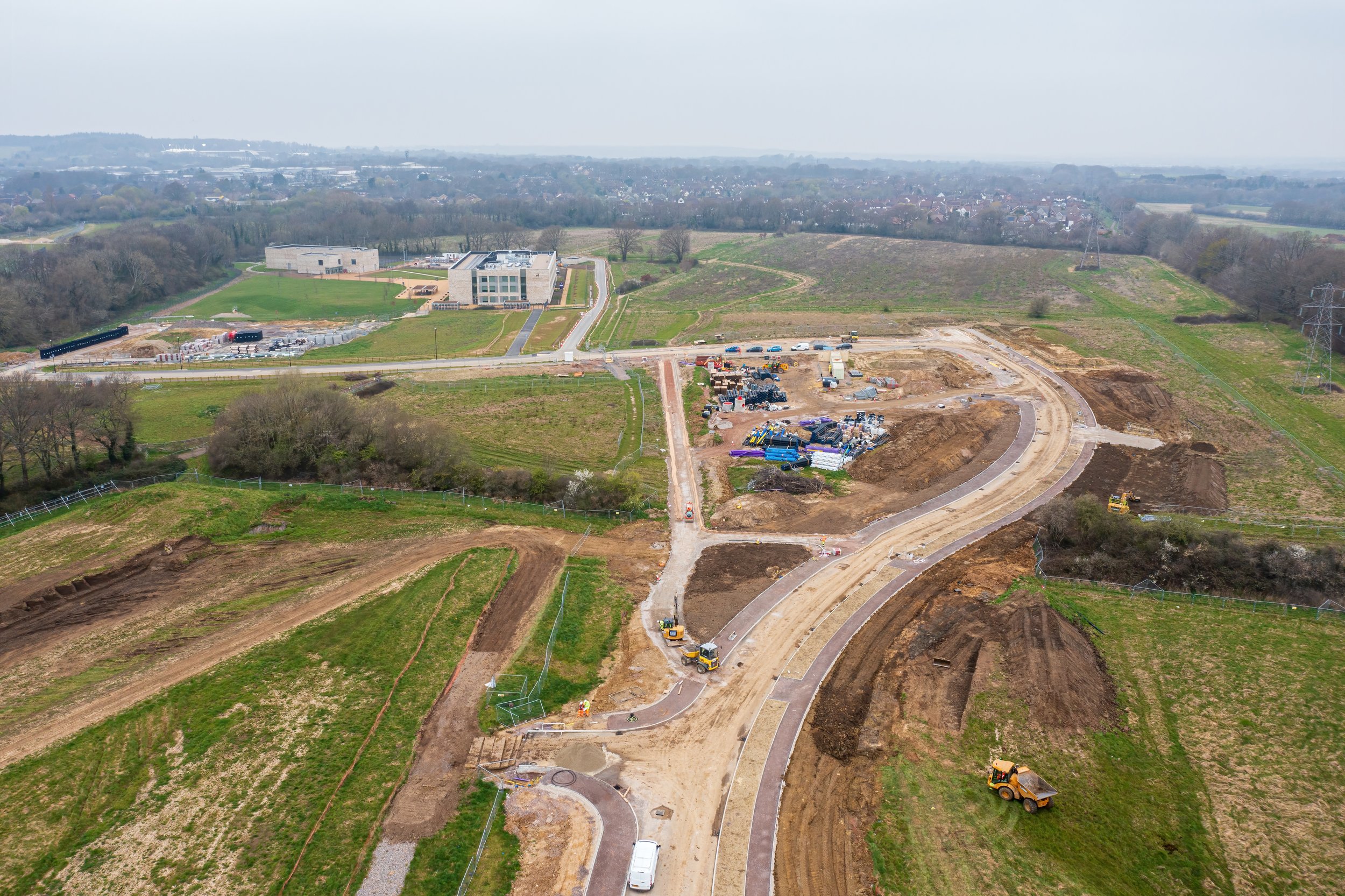

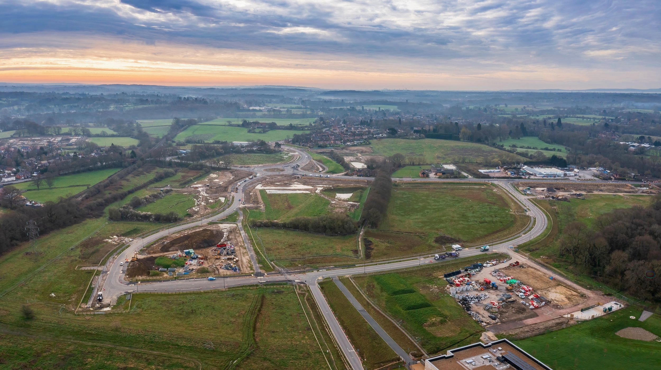
A new road layout in Hedge End area, Hampshire captured by drone
Drone Survey
With a Drone Survey using Aerial Photography and Aerial Videos the client can show updates of the project to the council on a regular basis and also have a record of what were done on site at different stages of the project. A drone view of the area can easily show where surface water accumulating or other issues that might arise.
Some of our Clients


FAQ’s
-
We are based in Hampshire and receive most of our work from the South of England but we have done projects throughout the UK.
Areas we cover:
Lyndhurst, Ringwood, Chichester, Worthing, Gosport, Brockenhurst, Lymington, Petersfield, Andover, Chandler’s Ford, Farnborough, Portchester, Whiteley, Cosham, Fareham, Botley, Hedge End, Eastleigh, Southampton, Weymouth, Swanage, Wareham, Lyme Regis, Wimborne, Christchurch, Dorchester, Somerset, Basingstoke, Portsmouth, Winchester, Salisbury, Poole, Bournemouth, Isle of Wight, Cornwall, Devon
-
We do drone photography, drone surveys, drone and aerial inspections, landbase photography, product photography, aerial photography, 360 Virtual Tours, Google Business Profile, Google Street View Tours, Headshots and Portrait Photography
-
Not at all. We have an open mind to any size projects, from small to large. We have the resources to take on any size project.
-
Yes we are insured for Public Liability up to £10 million.
-
We work with any type of business. From schools, heritage centres and railways, hotels, SME’s, holiday homes, B&b’s, Game Reserves and golf courses.
-
We offer roof surveys, drone photography, drone videos, drone images and videos for insurance purposes, building projects and more. Get in touch to discuss your project needs. We can usually help.
